Health & Fitness
North Hills Flashback: Lost Perrysville
In 1940, proposals for new residential construction in Perrysville called for great expansion of the little village. However, those plans never quite took shape.
The year is 1940. The worst of the Great Depression is now safely behind us. With a country just begging to be built up again, it’s time to think about expanding into suburbia.
Perrysville is the perfect place for some new growth. Already an established town on the fringe of Pittsburgh, the little village is in a time of transition. Landowners are selling their plots, allowing for new residential developments. It’s time to turn a town once termed “the gateway to the country” into the heart of northern suburban Pittsburgh.
First, let’s look at the west side of Perry Highway. We’ve got Atlantic Avenue, running in between the White House Hotel and a hardware store we call Vater’s in 2012. In development are a handful of new streets and alleyways, all running north to south. Franklin Way was to run behind the main road, followed by First Street (backed by Leland Way), Second Street (backed by James Way), Third Street (backed by Mulberry Way), and Fourth Street (backed by Ferguson Way). Henry Street backs the development, which features Mildred Avenue and Scott Street on either side (with Atlantic running down the middle and bisecting the north-to-south streets).
Find out what's happening in North Hillswith free, real-time updates from Patch.
With over twenty properties on each numbered street, this new neighborhood is convenient to St. Theresa Parish and School, Perrysville Public School, and the heart of the Perrysville Business District.
Next up is the east side, with a new development anchored by Good Way as the northern end of five streets. From west to east, we’ve got Ridge Avenue, an unnamed road, Willow Grove Avenue, Homer Avenue, and Grandview Avenue. With plenty of property waiting to be sold, these five streets could continue to expand south.
Find out what's happening in North Hillswith free, real-time updates from Patch.
Brandt Street, of course, uses Good Way as its southern terminus. Why not expand that area as well? We’ve got Fairdale Street, which connects Good and Bernice. Let’s build another street behind eastern Bernice and call it Greyledge Drive. We’ll connect it with Hillcrest Street.
Of course, we need some bigger properties too. Second Avenue, also connected to Brandt, has some room to branch out. Let’s get an eastbound street called Conrad Avenue and fill it up with some larger homes. We’ll even throw in a street to connect it to Reel Avenue, which we’ll extend and connect to First Street, giving us easy access to Three Degree Road.
Time to go forward to 2012. Ridge Avenue, Greyledge Drive, Hillcrest Street, and Conrad Avenue were never constructed. Atlantic Avenue terminates just west of Vater’s Hardware. In fact, no plan was ever built on the west side of Perry Highway in that location. What happened?
First, the actual developments. Instead of Ridge Avenue, we got Valley Drive, presumably because it was easier to construct given the geography of the valley (pardon the redundancy). Ridge Avenue looks as though it could have been a rear access road or even an alleyway for the homes on Valley Drive. However, it was probably viewed as unnecessary once the plan took shape.
Follow us on Twitter | Like us on Facebook
Good Way was to extend past Fairdale Street with plenty of property. However, it was instead built as a cul-de-sac on its easternmost point. Hillcrest Street (not to be confused with the street of the same name which does indeed exist slightly south of the proposed road) became Crestnol Drive, another no-outlet street. Greyledge Drive was never built, nor was Conrad Avenue or the Reel Avenue extension. We got Neola Drive instead, although the lost influence of the original plan can still be seen today, both in the location of Elrose Drive (if an imaginary connection between Elrose and Crestnol is made, it looks somewhat like Greyledge should have) and in another "road" which almost looks like it began as part of the proposed project.
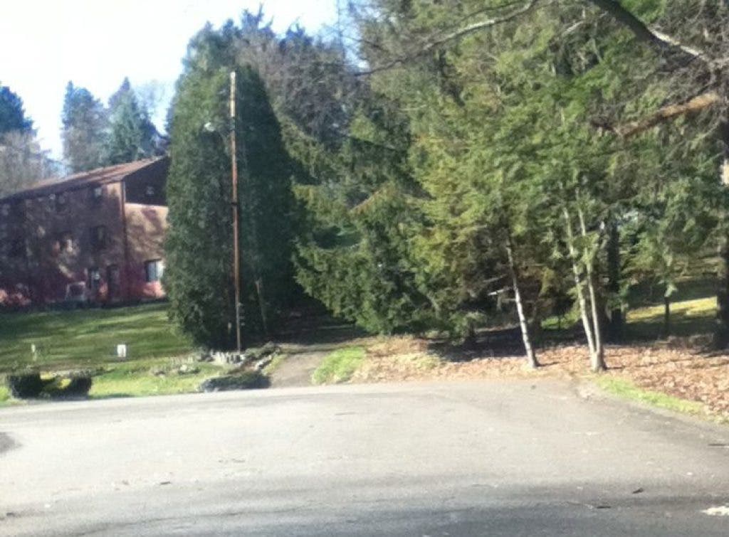
Take a look at the attached photograph. The small paved section between the trees, which connects Neola and Second, is right about where Conrad should have been. Today, this functions as a way for pedestrians to travel between the two streets. Apparently, there are other “ghost sections” of roads around the area as well.
The big question as to why these plans were never followed through--why?
First, take a look at the timeframe. When the United States entered World War II, everything necessary for construction suddenly disappeared, from the building supplies to the men who would have built the homes. (The Steagles, food ration stamps, steel pennies, and silver nickels were everyday reminders of these shortages). With the war the country’s number one priority, nobody was really focused on developing a few housing plans in suburban Pittsburgh.
When the war ended, the suburban movement began. However, by 1946, trends had changed in housing. Alleyways were a thing of the past, replaced by built-in or attached garages. Cul-de-sacs replaced the old gridlike layouts over time, giving more of a community feel. (Another feature not present on the 1940 map was Scharmyn Park, which, along with the Cedar Drive cul-de-sac, ultimately was built on plots which had yet to be sold to developers at the time).
There were probably some political reasons for the lack of construction as well. While I cannot confirm anything, I am willing to bet the Atlantic Avenue plan was never developed because of some sort of land dispute with St. Teresa, one of Perrysville’s longtime powerhouses on the western side of the main road. The Conrad Avenue plan may not have materialized at the time since many of the major landowners of the day had plots along the road itself (including big names such as Reel). While I have no definite history of how this land was broken up over time, the properties were completely built up in their current form just a few decades after the maps were published.
It’s interesting to look at these old drawings and think about what could have happened. For me, the town of “Lost Perrysville” makes for a good setting of a story. It’s a town which existed in the minds of real estate developers many years ago but never materialized. For everyone, it raises some “what if” questions. What if there was an entire development behind Vater’s? Could it have expanded over time? How would it have impacted the businesses and traffic along Perry Highway? Perhaps it would have housed enough families with children to have saved Perrysville Elementary (which has since been reincarnated as a Montessori School).
I would love to gather more information about these plots of land and why the proposed development never occurred. If you are familiar with these developments, please feel free to comment and provide some insight.
NEXT TIME: Going back to 1988, I’ll be sharing some memories of a great tradition of Perrysville past. At one time, Route 19 was closed down for a few hours every October. Why would anyone shut down the main road? Find out in the next edition of North Hills Flashback!!!
A SOURCE WORTH READING:
The streets referenced were found on the following 1940 map:
